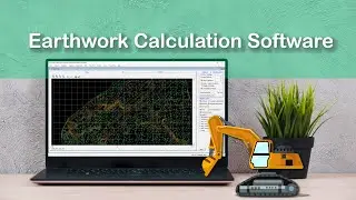
Mark Chainages along Alignment - Road, RailRoad, Canal
Mark Chainages along alignment using ESurvey CADD in Road, Rail Road, and Irrigation Canal Projects. The first step in Quantity Calculation Project in Infrastructure Engineering is to divide the whole alignment into multiple chainages at a given interval say 30 M. It can be done easily with AutoLisp Utility Provided within ESurvey CADD Package.
Read More:
https://esurveying.net/interpolation-...
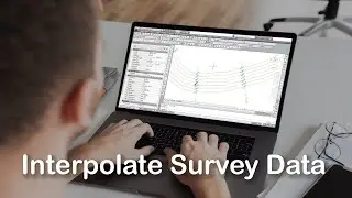
Preparing Data for Interpolation
Welcome to a video tutorial on how to prepare data for interpolation along an alignment. This involves 2 simple steps
a) Mark Chainages along the alignment
b) Create offset lines and move entities to specific layers
Mark Chain ages along the alignment (MCH)
In the road, railway and canal projects cross-sections are created at fixed distances, say 30M and the area computation is done in these cross-sections and then the volume is computed depending on the area. Normally the survey is also done at those fixed distances only. However, it is not possible to Exactly survey on the points at those distances and their respective offsets. Using the ESurvey CADD Interpolation module interpolating the values is easy.
Type ‘MCH’ (Mark Chainages) at the command prompts. A window will appear expecting inputs like Prefix, Suffix, Starting Chainage, Increment Etc. Please specify Cross Section Interval in Increment and Cross-section line length as per the project requirement. Click on Ok, and then select the alignment. You may not that program will create cross-section lines (that is Chainages) along the alignment. Depending on the input values Label indicating the Cross-Section value is also marked.
Create offset lines and move entities to specific layers
For interpolating multiple values, ESurvey CADD expects layerisation of Text and lines. All the cross-section lines need to be in the ‘CS’ layer. The central line that is alignment line needs to be in the LS layer. You can offset the center line on either side depending on offsets at which you want to interpolate the values. In this example, you can note that the centerline is offset at distances 2, 4, 7 and 10 on either side. These offset lines to be present in the “Offset” Layer. Elevation texts representing the surface should be in the ‘Elev’ layer. Once the text and lines are in ‘LS’, ‘Elev’, ‘Offset’ and ‘Elev’ layer, you are ready to interpolate values in bulk.
Thank you for watching this video. In the next video, you will learn how to interpolate values using the straight-line method.
Read More:
https://esurveying.net/interpolation-...
Смотрите видео Mark Chainages along Alignment - Road, RailRoad, Canal онлайн, длительностью часов минут секунд в хорошем качестве, которое загружено на канал ESurveying Softech (India) Pvt. Ltd. 21 Сентябрь 2015. Делитесь ссылкой на видео в социальных сетях, чтобы ваши подписчики и друзья так же посмотрели это видео. Данный видеоклип посмотрели 10,139 раз и оно понравилось 36 посетителям.


![Generate Cross Section Drawing in AutoCAD from Excel [Software]](https://images.reviewsvideo.ru/videos/DHNsVKbI4-w)


![Extract Elevations from Google Earth [Easy Way]](https://images.reviewsvideo.ru/videos/Xj86tzCpgbI)