Participants have joined from 🇨🇳 🇮🇳 🇸🇦 🇳🇵 🇵🇱 🇲🇲 🇿🇦 🇻🇳 Upcoming batch start on 15th November
Participants have joined from 🇨🇳 China, 🇮🇳 India, 🇸🇦 Saudi Arabia, 🇳🇵 Nepal, 🇵🇱 Poland, 🇲🇲 Myanmar, 🇿🇦 South Africa, and 🇻🇳 Vietnam Upcoming batch start on 18th October.
Registration Information check from here: https://www.studyhacksgeospatial.com/...
Registration is now open for a new batch of our 7-day online live training on Google Earth Engine for Remote Sensing and GIS Analysis! This course is designed for beginners to advanced learners, and is perfect for those with no prior programming experience. Enhance your knowledge and explore the latest advancements in geospatial technology.
Class Start: 15th November, 2024
Admission Last Date: 14th November, (1st 10 registered people get 50% discount).
For registration contact this WhatsApp number: +8801780-942798 or email: [email protected]
Total Class: 7 days (Friday and Saturday in Week)
Class Duration: 4 hours (Each day)
Time: 9:00 P.M (GMT +6)
Training language: English
For more details visit our website: https://www.studyhacksgeospatial.com/...
Online Training Benefits
Ø * Course Certificate (After submitting all Assignments)
Ø * Materials (Slide, PDF)
Ø * Practice Code (All codes provide)
Ø * Recorded Class (All class recorded video provided)
Ø * Lifetime teaching support
Course Content:
1st day:
Introduction to GES
How to use GEE JavaScript and Python API
Learn the basic principles of JavaScript syntax and Python.
How to create the IDE for Google Earth Engine python API.
Client vs. Server object on GEE
How you get the server to execute your code?
Importing Raster and Vector Data: Local storage & GEE Dataset
Filtering Attribute Table from shapefile or Geodatabase
2nd day:
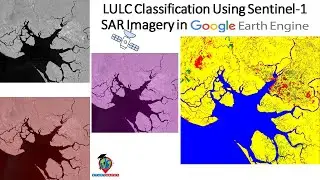
Filtering and Displaying Satellite Images: Landsat, Sentinel, Modis
How to merge Landsat-5 , Landsat-7, Landsat-8 and Landsat-9 and make the annual Image collection
Single date Satellite Images
Satellite Composite: Mosaic, Median, Mean
Band combinations
Export Satellite Imagery: Landsat , Sentinel and Modis
Import, Filter, Reduce, Clip and display Raster data in GEE
Time series Chart of NDVI using GEE readymade dataset
Export Any Shapefile
3rd day:
Calculating Any Indices from Satellite Images using Landsat and Sentinel
Filtering and Displaying Satellite Images: Sentinel-2 and Monitoring NDWI , NDVI and Time series chart of NDWI and NDVI
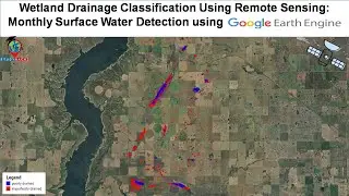
Flood Mapping using OTSU.
Extract water body using Thresholding and calculate the water surface area.
NDVI , NDWI , SAVI and all indices Time series Chart using Landsat and Sentinel
Export Any Shapefile from GEE
How to add Gradient Legend and Title on GEE
NDWI Calculated from Modis and Landsat data
4th day:
How to remove cloud and Haze from satellite imagery- Landsat and Sentinel
Visualization (DEM) of Hill shade and Slope Map in GEE using NASA SRTM and Aster
Land surface temperature (LST) Monitoring from Landsat satellite imagery and Modis
Urban Heat Island (UHI) and UFTVI Monitoring using GEE.
How to calculate Average, Maximum, Minimum NDVI any specific region.
GEE: How to make monthly Evapotranspiration.
5th day:
Air Quality Monitoring: all parameters
Particulate matter 2.5 or PM2.5 monitoring and time series chart.
How to Download Air Quality parameters Time series data in CSV format using GEE.
Air Quality Monitoring Time Series chart
Air Quality Monitoring: How to calculate total emission of nitrogen-oxide or any gases in GEE using sentinel-5
ArcMap software: How to make research paper map using GEE & ArcMap software.
6th day:
Introduction to Machine Learning in GEE
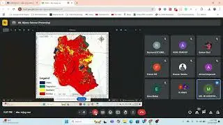
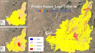
How to make LULC Map using Machine Learning: Supervised and Unsupervised algorithm
Random forest, CART, SVM, Minimum distance classifier to make LULC
How to Check LULC accuracy assessment using GEE. (Kappa, Producers & Consumers accuracy)
Calculate LULC classes Area
How to add Legend in LULC Map
How to Export LULC and make research paper LULC map using ArcMap
7th day:
Land-Use and Land-Cover Change Detection using GEE
NDVI change detection using Google Earth Engine
NDVI Classification using GEE
Extract the dense Vegetation using GEE and Calculate the area
Class-wise LULC change detection in ONE layer using GEE
Hyper parameter Tuning for improving the accuracy of your machine learning model
Смотрите видео Participants have joined from 🇨🇳 🇮🇳 🇸🇦 🇳🇵 🇵🇱 🇲🇲 🇿🇦 🇻🇳 Upcoming batch start on 15th November онлайн, длительностью часов минут секунд в хорошем качестве, которое загружено на канал Study Hacks-Institute of GIS & Remote Sensing 01 Январь 1970. Делитесь ссылкой на видео в социальных сетях, чтобы ваши подписчики и друзья так же посмотрели это видео. Данный видеоклип посмотрели 107 раз и оно понравилось 4 посетителям.