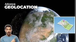
HOW TO SET GEOGRAPHIC LOCATION ON AUTOCAD DRAWING
#THE_SOLUTION
#GEOLOCATION
#AUTOCAD_TUTORIAL
#AUTOCAD_ADVANCE_TUTORIAL
#GOOGLE_MAP
#BEINGMAP
#AutoCAD
#CAD
#drawing
#location
#geographic
#map
#coordinate
#place
#situate
#position
#latitude
#longitude
#X #Y
#coordinateSystem
#point
#line
#region
#area
#territory
#boundaries
#border
#perimeter
#outline
#demarcate
#mark
#designate
#define
#mapCoordinates
#plotCoordinates
To Set Geographic Location from a Map
How do I change the geographic coordinate system in AutoCAD?
Open the Settings tab in the Toolspace. Right-click on the DWG and "Edit drawing settings". Select a projection and coordinate system on the first tab of the dialog.
You can insert geographic location information to a drawing file by specifying the location of a reference point on a map provided by an online maps service.
Note: You must be signed in to your Autodesk account to use the online maps service.
Click Insert tab Location panel Set Location drop-down From Map. Find
If the Geolocation - Online Map Data task dialog box displays, click Yes.
In the Geographic Location dialog box, in the Address box, type the name of a landmark or road near the reference location and click ok.
Tip: If you know the latitude and longitude of a nearby location, you can search for that as well.
In the results pane, on the result nearest to the reference location, click Drop Marker Here
A marker is inserted in the map.
Tip: Instead of searching, you can zoom the map, right-click the location and click Drop Marker Here.
-Zoom the map such that the marker and the location to set are clearly visible.
-Drag the geographic marker to the desired location.
Tip: Instead of dragging the marker, you can right-click the desired location and click Move Marker Here.
Click Next.
In the GIS Coordinate System list, select a coordinate system.
Tip: The coordinate system that has its datum closest to the marker location provides the best results. By default, this is the first coordinate system in the list.
Click Continue.
In the drawing area, click the position corresponding to the location you selected in
step 6.
At the command prompt, enter the angle from the X axis to the north direction.
#Autocad_geolocation
#geolocation
#geolocation_in_cad
@civilbeings @bdlandsurveyor8067 @surveyingengineeringdesigninfo @CADLearning @LucasNajleTutorials @CivilTechSource @CadisticEnglish @Cadistic
UTM TO LAT,LONG/LATLONG TO UTM CONVERTER :
DOWNLOAD LINK : 1 ) DRIVE : https://drive.google.com/drive/folder...
DOWNLOAD LINK : 2) BLOGGER :
https://thesolutiontutorial.blogspot....
Autodesk Autocad 2015-2018 geolocation online map hotfix
DOWNLOAD LINK : 1) DRIVE :
https://drive.google.com/drive/folder...
DOWNLOAD LINK : 2) BLOGGER :
https://thesolutiontutorial.blogspot....
Another video AUTOCAD DWG TO KML GOOGLE EARTH
VIDEO LINK :
• AUTOCAD DWG TO KML GOOGLE EARTH
Stay connect with us
Watch video HOW TO SET GEOGRAPHIC LOCATION ON AUTOCAD DRAWING online, duration hours minute second in high quality that is uploaded to the channel THE SOLUTION 05 July 2020. Share the link to the video on social media so that your subscribers and friends will also watch this video. This video clip has been viewed 2,955 times and liked it 30 visitors.


![[FREE] Fivio Foreign Type Beat -](https://images.reviewsvideo.ru/videos/jGnEikKBKbg)